Sunday, September 28, 2014

A Day on the Farm

My day at Schaeffer Farms did not go well. 

Schaeffer Farms is potentially the best mountain biking park in our area. Located in the hinterlands (out beyond Gaithersburg), Schaeffer Farms is a park that is a farm that is a mountain biking course. 15 miles of rolling trails wind their way through woods, creeks, farmland and cornfields, giving cyclists different levels of terrain and difficulty. The average grade is 2.8% (a bit more than train grade) while the steepest grade is 8.1%. Trails wind and climb through creeks, bridges, boulders, and trees, giving skilled cyclists ample opportunities to crash. 

The trail network in Schaeffer Farms was built by Mid-Atlantic Off-Road Enthusiasts (aka MORE) in cooperation with the Department of Natural Resources. The MOCO Epic  mountain bike race starts and finishes at Schaeffer Farms. 

Excited for a day on the trails, I attempted to turn my "hybrid" Cannondale Bad Boy into a cross-bike, swapping on 33 nobbies for my 700 wheels. Well guess what…. they didn't fit. Even though the Cannondale is a "hybrid," simply moving up to 33s was too fat for the bike. Apparently, "hybrid" means I can put on mountain bike tires if I drop down to 26" wheels. Well.. great

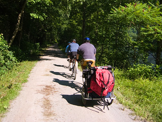
I wasn't going to give up on the day, and by cycling partner had already hit the trail with his new crossbike - so I attempted to mountain bike on my 700 x 28c tires. The Bad Boy is a good bike made to take abuse, and abuse it I did. I did a good route over the river, er creeks, and through the woods. It was an excellent ride and I am proud to say I did not crash into any trees. However, the terrain clearly dictated riding on nice soft balloons (mountain bike tires). Afraid of damaging my rims, I called it a day. 

My cycling partner, however, had skillfully failed to avoid the tree that leaped out into the trail in front of him. 

Schaeffer Farms is an excellent mountain biking park. Time for Rule #12

Sources: 

Thursday, September 25, 2014

Stay Safe: Courtesy of the W&L Bike Club #bikedc

The Fall Equinox brings shorter days.  Shorter days brings darkness.  Darkness brings bike lights.

Celebrating the Fall Equinox, the Washington & Lee Generals Bike Club, in cooperation with Bike Arlington, recently decorated student bicycles parked in front of Washington & Lee High School with lights and reflective give aways. 

One of the truly incredible things about this the tremendous number of bicycles you see in front of W&L every day.  APS recently installed a new bicycle rack in front of the school, increasing the parking capacity at that spot by approximately 50%.  And already the new rack is full every morning.  Cycling to school at W&L is booming and growing.

The Bike Arlington program of giving away bicycle lights and reflectors is an excellent investment in promoting safe cycling in Arlington.  Commuting home, I regularly see these lights on bikes, turning invisible "ninjas" on the trails into PALs. Giving lights to students is great way of promoting safe routes to school.

Nice job W&L Bike Club!


Wednesday, September 24, 2014

Arlington County Board Approves Easement for Washington Blvd Trail #bikedc @arlingtonva

The Arlington County Board in its meeting this week reportedly approved of an easement from the Navy along Washington Blvd in order to accommodate a new multi use trail for pedestrians and cyclists.  From the Board's agenda:
Deed of easement amendment 001 for public recreation, pedestrian and bicycle path on property owned by the United States Government and located on the Naval Supply Facility, Arlington, Virginia, RPC #34-013-001.
C.M. Recommendation:   Approve the deed of easement amendment 001 (attached to the staff report) for public pedestrian and bicycle path (amended deed) on property owned by the United States Government and located on the Naval Supply Facility, Arlington, Virginia, RPC #34-013-001. In addition, authorize the Real Estate Bureau Chief, Department of Environmental Services, or his designee, to accept, on behalf of the County Board, the Deed of Easement attached to (the) Board Report as Attachment 1, subject to the approval as to form by the County Attorney.   

Photo by BankBryan (cc Flickr)
This is an important connection between the Rosslyn-Ballston Corridor and the Pentagon City area going North-South. This clears the way for the construction of the trail to be placed out for bid, with a potential completion date for the trail of the summer of 2015.

ArlNow recently reported that the path of the trail had been realigned in order to avoid the removal of multiple mature trees, but also necessitating the acquiring of the easement. 

This will be a tremendous addition to the Arlington trail system.  The Arlington Loop (the MVT, the Custis, and the WOD) has created a heavily used beltway of cyclist transportation along with a recreational opportunity for joggers, dog walkers, skaters, and pedestrians.  When bike commuters are polled where they come from, they predominately answer from along the trails.  Smart infrastructure leads to smart cycling transportation.

What is missing - badly missing - is a trail through the center of the county along Washington Boulevard.  A North-South trail will be another huge step forward in Arlington's cycling infrastructure, making access to everywhere in the county easy by bicycle.

Monday, September 22, 2014

How Would You Fix the Intersection of Doom? Updated @voteforvihstadt @alanhowze #bikedc #arlingtonva

When last these two candidates met in an election, we asked them a series of questions about cycling in Arlington.  You can read their responses, linked below.

This election, we have asked them a simple question:  How would you fix the intersection of doom?

Here are their response tweets so far:

Photo by Alyson Hurt (cc Flikr)
Alan Howze || Previous Response
long-term reroute. Short-term implement adopted changes + signal changes (NPS/VDOT) so cars not turning right into bike/ped +

+ enhanced enforcement + detailed data collection on incidents across Arlington tinyurl.com/nv5s86t

+ safe streets across all of Arlington - not just trails - safe routes to school, work, etc - much more we need to do!

as a bike commuter I am very familiar with the intersection and its dangers for cyclists, pedestrians and runners. 
 John Vihstadt || Previous Response
Thanks for writing. @ArlingtonVA staff working to improve @RosslynVA #IntersectionOfDoom. Asked for update. Will report back.
The Intersection of Doom has been a problem for decades.  1000s of cyclists and pedestrians go across this intersection daily.  Because the infrastructure is terrible, they get forced out into the street, they get hit, and then they get ticketed by a callous NPS cop who cant figure out that its not a pedestrians fault when the infrastructure is terrible. In other major urban environments, a dangerous or congested intersection would have a traffic officer assigned to facilitate traffic flow. For as long as I have lived in Arlington, the County has promised that solutions are on the horizon.  Meanwhile, crossing the Intersection of Doom is a form of Russian Roulette.  Arlington County claims to be going for the gold certification for a Bike Friendly Community - they even - almost ironically - constructed a cycling totem pole at the Intersection of Doom spending piles of money on a counter instead of spending piles of money on risk mitigation and safety.

We are Arlington cyclists.  We are frustrated.  We want to know: How will you fix the Intersection of Doom.

Candidates, we will be glad to post any updated responses. 

Riding the GAP

The C&O Trail many of us know. The C&O Trail is the towpath to the C&O canal, running 184 miles from Georgetown through Harpers Ferry west to Cumberland. It is simultaneously a wondrous experience to explore the nature along C&O and Potomac river, and near death-by-vibration. The C&O trail surface is hard pack dirt, clay, rocks, roots and whatever else might be available that, while relatively flat, can come very close to a mountain biking experience.

Photo by Jason Pratt (cc Flickr)
The C&O canal made it as far west as Cumberland, and that is where the Western Maryland Railroad picked up, serving the iron, steel, and coal industries. As those industries closed, and the costs of the railroad became unsustainable, the Western Maryland Railroad merged with CSX, and the Great Allegheny Passage (GAP) line was abandoned. The first section of this rail line to be converted to a trail was a 9 mile section near Ohiopyle (a recreation mecca and near Frank Lloyd Wright’s Falling Water). The entire trail was completed in 2006, with the last 9 miles opening at Cumberland. In total,GAP trail takes willing wheelmen 150 miles to Pittsburgh with approximately 1300 feet of elevation change.

I started my short journey along the GAP from Cumberland. This is a town that understands and has benefited from bicycle and recreational tourism. At the center is the old trail station and a nice park with a bike shop, many good restaurants, and hotels. Departing Cumberland, the trail is in far better condition than the C&O. I rode comfortably on 28c tires at 100 psi over the surface of crushed limestone and asphalt.

The trail out of Cumberland involves climbing a steady steady less than 2% grade climb for 23 miles. The grade is optically deceiving; you cant necessarily tell that you are climbing other than you feel like you are dragging a sack of concrete behind your bike. I actually got off of my bike to make sure my brakes were not rubbing. As much as the climb up the hill can be a grind, the ride back down is a throw-back to childhood (its like flying down the neighborhood hill on a Big Wheel only the ride is 30 minutes long).

This is a journey into a wondrous land of imagination. After mile 5 you will come upon the Brush Tunnel, and further along you will pass the Cumberland Bone Cave where bones from 41 genre of mammals were uncovered. The Great Western Railroad will follow you up the mountain until Frostburg (if you want to cheat, you can take the railroad up to Frostburg, get off, and start your ride). After Frostburg comes the Borden Tunnel and the Big Savage Tunnel, which is the longest tunnel along your journal at 3294’. At about mile 23 you will cross over the Eastern Continental Divide. You will wind through the mountains, bridges and along farms. Your companions will be many other through-cyclists and hikers, and cows.

There are plenty of services along the trail and businesses that cater to recreational tourism. The trail meanders through small towns about every ten miles where lodging may be available, or cyclists can pack and camp along the trail.

Sources: 


Saturday, September 20, 2014

Arlington Bd Candidates: How Would You Fix the Intersection of Doom?

Once again it is election time in Arlington for the Board. In the past I circulated to candidates an interview of questions on how they support cycling.  But these candidates have already answered that survey.

So this time, I asked both candidates one simple question:  how they would fix the Intersection of Doom. (and dont be like other poseur candidates who did not even know what the Intersection of Doom is)

Initially only John Vihstadt responded.  His response was to punt and say county staff were studying the issue.

Today I asked both candidates again. 

Howze just answered "Upgrades adopted this year for 2015 completion - infrastructure and signaling. Open to your suggestions?"  He too attempts to punt by flipping the question, indicating that he does not have a clue.

Candidates.... we await your answer.

Friday, September 19, 2014

Arlington BAC Happy Hour Sept 23rd

Sez the Arlington BAC
Since we didn't have a regular September meeting, the Arlington Bicycle Advisory Committee decided to hold a Happy Hour event. 
We'd love you to stop by and chat all things Arlington biking! Bring friends...bring family...bring your bike!
Chevy's Pentagon City6:30pm - 8:30pm
Fiesta platters courtesy of Bike Arlington. Bueno!Happy Hour specials courtesy of Chevy's who will be extending them into our event space.
Since it's only a short ride away be sure to check out Arlington's first protected bike lane on S Hayes St between 15th St S and S Fern.
More details on the Facebook event page.

Who/What is the BAC?
The Bicycle Advisory Committee, with roots in the community, helps focus continuing attention and resources on the role of bicycles and bicycling for transportation, health, and the enjoyment of parks and other public facilities in Arlington County, a national leader in urban planning and livable community design.
The BAC advises the County Manager on issues that affect cycling in Arlington County, including, but not limited to: safety, education, community involvement, awareness and promotion, and the development, operation and maintenance of on- and off-street bicycle transportation and recreation facilities.
Regular BAC meetings occur the first Monday of the month from 7:00 - 9:00pm at 2100 Clarendon Boulevard.
Learn more: http://www.bikearlington.com/pages/b...ory-committee/

Arlington Family Fun Ride ~ Oct. 4

The Arlington Fun Ride is Saturday October 4, starting at Crystal City.  The full bike route follows the 16 mile Arlington Loop. There is also a kids route in conjunction with Arlington Kidical Mass.

Time: Adult & Youth Ride Starts at 8am.  Kids Ride starts at 10am.
Where: Crystal City: 18th Street and Crystal Drive
Cost: $10 for individuals, $25 for families (up to 4 individuals) and includes a technical t-shirt for each individual. Additional shirts are available at $10 each (supplies are limited)
The Arlington Fun Ride is a scenic, family-friendly 16-mile ride taking you on the paved multi-use trails that make up the Arlington Loop. There will be multiple pit stops with snacks along the ride and at the start/finish there will be health and fitness information and activities for all ages, including music, games, a kids bike rodeo and a short family ride for parents with small children.